Kemmangundi
Kemmangundi is a hill station in Tarikere taluk of Chikkamagaluru district, Karnataka. Kemmangundi is located at a height of 1434m above sea level. This was the summer retreat of Krishnaraja Wodeyar IV and as a mark of respect to the king, it is also known as Sri Krishnarajendra Hill Station. Ringed by the Baba Budan Giri Range and blessed with silver cascades, mountain streams, and lush vegetation, Kemmangundi's beautifully laid-out ornamental gardens and enchanting mountains and valleys views are a treat to the eye. The spectacular sunset view from the Raj Bhavan is a photographer's delight. For the adventurous at heart, Kemmangundi offers many peaks to scale and intricate jungle paths to explore.

The pleasant weather and the scenic beauty inspired the erstwhile ruling Maharaja of Mysore to build a summer palace here. He took great care, maintained the natural surroundings, landscaped the gardens, built good roads and other conveniences, necessary for a comfortable stay. After ten years of owning Kemmannagundi, he donated this land of God's gift to the Government of Karnataka. The Horticulture Department develops and maintains the resort and the environment. Kemmannagundi is also named Sri Krishnarajendra Giridhama after his Highness. Kemmannagundi, 'The Queen of Hills' allures you with her green dense forests, fragrant flowers, rolling pastures, springs, cliffs, caves and thick clouds hanging gently over hill tops. Kemmannagundi is situated in Tarikere taluk, Chikkamagaluru district of Karnataka. It is about 252 kilometers from Bangalore, the capital of Karnataka. It is 1434 meters above sea level. The maximum temperature during summer is 28 degree centigrade, and it receives a yearly rainfall of 254 cms.
Kemmangundi (or Kemmanagundi) derives its name from three Kannada words - Kempu (red), mannu (soil) and gundi (pit) and means a place with red soil.
Places to See in Kemmangundi
Its worth listing some of the tourist spots in and near Kemmangundi.
Raj Bhavan: Raj Bhavan is a guest house located in Kemmangundi and offers a spectacular view of the surrounding hills. The view of the sunset from Raj Bhavan is something to be cherished.
Z point: Z point is a vantage point at Kemmangundi and can be reached by a steep uphill trek of about 30 mins. from Raj Bhavan and is another favourite place of people who want to view a spectacular sunset.As itis a walk beware of slippery roads and snakes
Rose garden: Rose garden, as the name suggests is a garden of roses maintained by the Horticultural Department. Various varieties of roses are cultivated here.
Hebbe Falls: A downhill trek of about 8 km from Raj Bhavan takes one to Hebbe Falls where water streams down from a height of 168 meters in two stages to form Dodda Hebbe (Big Falls) and Chikka Hebbe (Small Falls). Jeeps are available from one particular point to Hebbe falls and they charge arount 700/- (for up and down). We can take a trek if you have enough time.
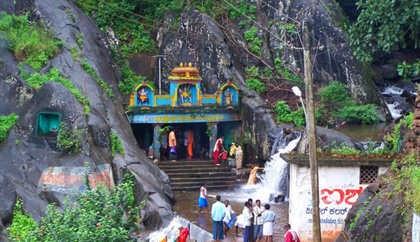
Kallathi falls: Kallathi falls is about 10 km. from Kemmangundi. On the road from Kemmangundi to Tarikere, a deviation takes one to Kallathi falls. It is also known as Kallathigiri falls and Kalahasthi falls. Water cascades from a height of 122 metres and the temple here is attributed to times of the Vijayanagar empire. According to a local legend, this place is associated with the Hindu sage, Agastya.
The Kalhatti falls from a height of about 400 ft amidst the Chandra Drona hills and is clearly visible from a far away distance. It is a multi tiered falls and at its lowermost tier is a temple dedicated to Veerabhadra Swamy (Lord Shiva). The Tamil inscriptions on the rock indicate an association of the temple with the Cholas.
Bhadra Tiger Reserve: Bhadra Tiger Reserve: A two-hour drive from Kemmanagundi will take you to India's 25th nature reserve - a vast expanse of bamboo trees surrounded by coffee plantations. A forest jeep could lead you to the elusive sight of a tiger. Don't be disappointed if all you can see is its pugmarks. Apart from the tigers, watch out for the elephants, deer, panthers, gaur, sambar, jungle cats and birds such as woodpecker, robin etc. More than 250 species of birds inhabit this forest.
Honnamma Falls: This is about 24 kilometers from Kemmannagundi, it is called Manikyda Dhare because the water falls as gently as a pearl drop. Legend also says that the fall was named after the saint Manikya Dhara.
Shanthi Falls: Shanthi Falls is a beautiful waterfalls 1 kilometer away from Kemmannagundi.
Bababudangiri: Bababudangiri is 24 kilometers from Kemmannagundi. It is situated 1864 meters above sea level. It also looks like a crescent moon.
This place is worshipped as the Mecca of the South by Muslims as the Tomb of Hajarat Dada Hayath Mir Kalandar is in the cave of this mountain. The Hindus too worship this place as 'Dattatreoya Peeta'.
Bababudan giri is also famous for coffee plantations. The first coffee plant was said to have been brought here by Hajarat Jamal Ullash Magarbi Bagada Diwali Khadri from Arabia. Mullayyana Giri near Bababudangiri is the tallest hill in Karnataka. It is 6,317 feet high. Another hill called the Kallahatta Giri is 6,115 feet high.
Horse way: A small narrow way in the creek of the hill is called the Horse way as the Maharajas used to go horse back riding here to view the spectacular sun rise and sun set.
Jagara Pass & Jagara Valley: 16 kilometers from Kemmannagundi, it is a beautiful green avenue. For wildlife lovers and enthusiasts, it is an ideal place to trek.
Shankar Sholapradesha: 5 kilometers from Kemmannagundi, the Horticulture Department has been producing true potato seeds in an area of 5 acres. In addition, various fruits, flowers and vegetables are also grown here.
Food Guest Houses & Accomodation in Kemmangundi
There are only government run guest houses at the hill station. They provide both food and accommodation. Prior booking is essential for staying. For booking during season contact Department Head Office,Lalbagh, Bangalore Ph 080-26611925, 26571925 Off season booking Horticulture Department Guest House, Kemmanagundi Ph 08262-24126, 235334 Other options for stay is at Chickamagalur.
How To Reach Kemmangundi
By road: Kemmangundi is about 53 km by road from the district headquarters of Chikkamagaluru town. From the state headquarters of Bangalore, one can try the following routes to reach Kemmangundi:
- National Highway NH-206 till Birur (229 km), take a deviation to Lingadahalli (16 km), turn left at Lingadahalli and you will see a signage (at around 1km) pointing you to Kemmannugundi. It's about 20km from this point on a rough road.
- National Highway NH-206 till Kadur and then taking a deviation to Chikkamagaluru and from there to Kemmangundi (300 km)
- National Highway NH-48 till Hassan and then taking the Hassan - Belur - Chikkamagaluru - Kemmangundi road (330 km)
There are two ways from Chikkamangaluru to Kemmanagundi. The one that goes via Lingadahalli is good and offer very scenic views. The other way is very very bad, better avoid it. Each one of the above routes offers a scenic drive through the mountain roads of Chikkamagaluru district and should be explored.
By rail: Nearest Railway Station is Tarikere (35 km. away)
By air: Nearest Airport is Mangalore (190 km. away). Alternatively, the airport at Bangalore can be used.
KSTDC Tour Packages to Kemmangundi
KSTDC 4 days Package Tour to Kemmangundi covers Kemmangundi, Bababundangiri, Kuppahalli and Sringeri. Tours are conducted from Badami House, Bangalore.
KSTDC Tour Packages to Kemmangundi
Hotels & Accomodation in Kemmanagundi
Route Map from Bangalore to Kemmanagundi
Temples in Kemmannagundi
Veerabhadreshwara Temple, Tarikere is set against the backdrop of the beautiful Kalhatti falls. The temple is constructed in a gap between two rocks.
Kemmanagundi Hill Station Nearest Sceneries - Tourism in Chikmagalur District - Popular Tourist Attractions in Kemmanagundi -